Discovery and early sightings
The island was discovered on 1 January
1739 by
Jean-Baptiste Charles Bouvet de Lozier, commander of the
French ships Aigle and Marie. This was the
first time that land had been spotted south of the
50th parallel south. Bouvet, who was searching for a
presumed large southern continent, spotted the island
through the fog and named the cape he saw
Cap de la Circoncision. He was not able to land and did
not
circumnavigate his discovery, thus not clarifying if it
was an island or part of
a continent. but
his plotting of its position was inaccurate
forcing several expeditions to fail to find
the island again. James
Cook's
second voyage set off from
Cape Verde on 22 November 1772 to find Cape Circoncision,
but was unable to find the cape.
The next expedition to spot the island
was in 1808 by James Lindsay, captain of the
Samuel Enderby & Sons' (SE&S)
whaler Snow Swan. They reached the island and
recorded its position, though they were unable to land.
Lindsay could confirm that the "cape" was indeed an island.
The next expedition to arrive at the island was American
Benjamin Morrell and his vessel
seal hunting ship Wasp. Morrell, by his own
account, found the island without difficulty (with
"improbable ease", in the words of historian William Mills)
before landing and hunting 196 seals. In his subsequent
lengthy description, Morrell does not mention the island's
most obvious physical feature, its permanent ice cover. This
has caused some commentators to doubt whether he actually
visited the island.
On 10 December 1825, SE&S's George
Norris, master of the Sprightly, landed on the
island, named it Liverpool Island and claimed it for the
British Crown and
George IV on 16 December. The next expedition to spot
the island was Joseph Fuller and his ship Francis Allyn
in 1893, but he was not able to land on the island. German
Carl Chun's Valdivia expedition arrived at the
island in 1898. They were not able to land, but dredged the
seabed for geological samples.They were also the first to
accurately fix the island's position.
Norris also spotted a second island,
which he named
Thompson Island, which he placed 72 kilometers (45 mi)
north-north-east of Liverpool Island. Thompson Island was
also reported by Fuller, but Chun did not report seeing such
an island, nor has anyone since. However, Thompson Island
continued to appear on maps as late as 1943. A 1967 paper
suggested that the island might have disappeared in an
undetected volcanic eruption, but by 1997 it was discovered
that the ocean is more than 2,400 meters (7,900 ft) deep in
the area.
Norwegian annexation
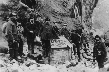
In 1927, the First Norvegia
Expedition—led by
Harald Horntvedt and financed by
Lars Christensen—was the first to make an extended stay
on the island. Observations and surveying were conducted on
the islands and
oceanographic measurements performed in the sea around
it. At Ny Sandefjord, a small hut was erected, and on 1
December the
Norwegian Flag was hoisted and the island claimed for
Norway. The annexation was established by a royal decree on
23 January 1928. The claim was initially protested by the
United Kingdom, on the basis of Norris' landing and
annexation. However, the British position was weakened by
Norris' sighting of two islands and the uncertainty as to
whether he had been on Thompson or Liverpool (i.e. Bouvet)
Island. Norris' positioning deviating from the correct
location combined with the island's lack of a
natural harbor and small size made the UK accept the
Norwegian claim. This resulted in diplomatic negotiations
between the two counties, and in November 1929, Britain
renounced its claim to the island.
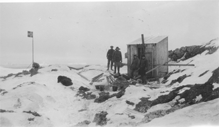
The
Second Norvegia Expedition arrived in 1928 with
the intent of establishing a manned meteorological radio
station, but a suitable location could not be found. By then
both the flagpole and hut from the previous year had been
washed away. The
Third Norvegia Expedition, led by
Hjalmar Riiser-Larsen, arrived the following year and
built a new hut at
Kapp Circoncision and on Larsøya. The expedition carried
out
aerial photography of the island and was the first
Antarctic expedition to use aircraft. The Dependency Act,
passed by the
Parliament of Norway on 27 February 1930, established
Bouvet Island as a dependency, along with
Peter I Island and
Queen Maud Land. The
eared seal was protected on and around the island in
1929 and in 1935 all seals around the island were protected.
Recent history
In 1955, the South African frigate
Transvaal visited the island. Nyrøysa, a
rock-strewn ice-free area, the largest such on Bouvet, was
created sometime between 1955 and 1958, probably by a
landslide. A scientific landing in 1978 measured the
underground temperature at
25 °C
(77 °F). The
island was visited by the British naval ship
HMS Protector in 1964. In addition to scientific
surveys, a
life raft was found at Nyrøysa, although no people were
found. The entire island and its territorial waters were
protected as a
nature reserve on 17 December 1971.
Since the 1970s, the island has been
frequently visited by Norwegian Antarctic expeditions. In
1977, an automated
weather station was constructed, and for two months in
1978 and 1979 a manned weather station was operated. The
Vela Incident took place on 22 September 1979 in the sea
between Bouvetøya and
Prince Edward Islands when the American
Vela Hotel satellite registered an unexplained
double flash, variously interpreted as a nuclear test,
meteor, or instrumentation glitch.
In March 1985, a Norwegian expedition
experienced sufficiently clear weather to allow the entire
island to be photographed from the air, resulting in the
first accurate map of the whole island. In the mid-1980s,
Bouvetøya,
Jan Mayen, and
Svalbard were considered as locations for the new
Norwegian International Ship Register, but the
flag of convenience registry was ultimately established
in
Bergen, Norway in 1987. Several amateur radio
DX-peditions have been conducted to the island. The
Norwegian Polar Institute established a 36-square-meter
(390 sq ft) research station, made of
shipping containers, at Nyrøysa in 1996. On 23 February
2006, the island experienced a
magnitude 6.2 earthquake whose epicenter was about 100
km (62 mi) away (originally reported as magnitude 5.5),
weakening the station's foundation and causing it to be
blown to sea in a winter storm. The 2004 film
Alien vs. Predator is set on Bouvetøya. In 2007, the
island was added to Norway's tentative list of nominations
as a
World Heritage Site as part of the transnational
nomination of the Mid-Atlantic Ridge.
Krill fishing in the Southern Ocean is subject to the
Convention for the Conservation of Antarctic Marine Living
Resources, which defines maximum catch quotas for a
sustainable exploitation of
Antarctic krill. Surveys conducted in 2000 showed high
concentration of krill around Bouvetøya. In 2004,
Aker BioMarine was awarded a concession to fish krill,
and additional quotas were awarded from 2008 for a total
catch of 620,000 tonnes (610,000 long tons; 680,000 short
tons). There is a controversy as to whether the fisheries
are sustainable, particularly in relation to krill being
important food for whales.In 2009, Norway filed with the
UN Commission on the Limits of the Continental Shelf to
extend the outer limited of the continental shelf past 200
nautical miles (230 mi; 370 km) surrounding the island.
The Hanse Explorer visited
Bouvet Island on 20 and 21 February 2012 as part of the "Expédition
pour le Futur". Four climbers (Aaron Halstead, Will Allen,
Bruno Rodi, and Jason Rodi) were the first people to climb
the 780 metre summit of the glacier capping the island. They
left a time capsule at the summit, containing visions of the
future for 2062. Aaron Halstead led five others (Sarto
Blouin, Seth Sherman, Chakib Bouayed, Cindy Sampson, and
Akos Hivekoviks) to the summit on the following day.
Geography
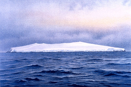
Bouvetøya is a volcanic island
constituting the top of a volcano located as the southern
end of the Mid-Atlantic Ridge in the South Atlantic Ocean.
The islands measures 9.5 by 7 kilometers (5.9 by 4.3 mi) and
covers an area of 49 square kilometers (19 sq mi), including
a number of small rocks and skerries and one sizable island,
Larsøya. It is located in the Subantarctic, south of the
Antarctic Convergence, which, by some definitions, would
place the island in the
Southern Ocean. Bouvet Island is the
most remote island in the world. The closest land is
Queen Maud Land of Antarctica, which is 1,700 kilometers
(1,100 mi) to the south, and
Gough Island, 1,600 kilometers (990 mi) to the north.
The closest inhabited location is
Cape Agulhas,
South Africa, 2,200 kilometers (1,400 mi) to the
northeast.
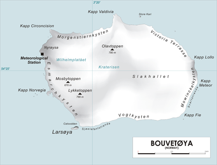
Map of Bouvet
Island, Southern Atlantic Ocean. Author:
varp
Nyrøysa is a 2-by-0.5-kilometer (1.2
by 0.3 mi) terrace located on the north-west coast of the
island. Created by a
rock slide sometime between 1955 and 1957, it is the
island's easiest access point. It is the site of the weather
station. The north-west corner is the peninsula of Kapp
Circoncision.From there, east to
Kapp Valdivia, the coast is known as
Morgenstiernekysten.
Store Kari is an islet located 1.2 kilometers (0.7 mi)
east of the cape. From Kapp Valdivia, southeast to
Kapp Lollo, on the east side of the island, the coast is
known as Victoria Terrasse. From there to
Kapp Fie at the southeastern corner, the coast is known
as Mowinckelkysten. Svartstranda is a section of
black sand which runs 1.8 kilometers (1.1 mi) along the
section from
Kapp Meteor, south to Kapp Fie. After rounding Kapp Fie,
the coast along the south side is known as Vogtkysten. The
western-most part of it is the 300 meters (980 ft) long
shore of Sjøelefantstranda. Off
Catoodden, on the south-western corner, lies Larsøya,
the only island of any size off Bouvetøya. The western coast
from Catoodden north to Nyrøysa, is known as Esmarchkysten.
Midway up the coast lies
Norvegiaodden (Kapp
Norvegia) and 0.5 kilometers (0.31 mi) off it the
skerries of Bennskjæra.
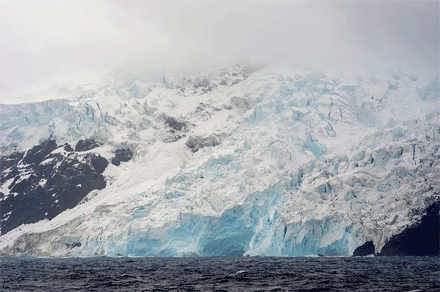
93 percent of the island is covered by
glaciers, giving it a domed shape. The summit region of
the island is Wilhelmplatået, slightly to the west of the
island's center. The
plateau is 3.5 kilometers (2.2 mi) across and surrounded
by several peaks. The tallest is
Olavtoppen, 780 meters (2,560 ft)
above mean sea level (AMSL),[26]
followed by
Lykketoppen (766 meters / 2,513 feet AMSL) and
Mosbytoppane (670 meters / 2,200 feet AMSL). Below
Wilhelmplatået is the main
caldera responsible for creating the island. The last
eruption took place 2000 BC, producing a
lava flow at Kapp Meteor. The volcano is presumed to be
in a declining state. The temperature 30 centimeters (12 in)
below the surface is 25
°C (77 °F).The
island's total coastline is 29.6 kilometers (18.4 mi).
Landing on the island is very difficult, as it normally
experiences high seas and features a
steep coast. During the winter, it is surrounded by
pack ice. The
Bouvet Triple Junction is located 275 kilometers (171
mi) west of Bouvet Island. It is a
triple junction between the
South American Plate, the
African Plate and the
Antarctic Plate, and of the Mid-Atlantic Ridge, the
Southwest Indian Ridge and the
American–Antarctic Ridge.Climate
The island is located south of the
Antarctic Convergence, giving it a marine
Antarctic climate dominated by heavy clouds and
fog.
It experiences a mean temperature of
−1 °C
(30 °F), with
January average of 1 °C
(34 °F) and
September average of −3
°C (27 °F).
The monthly high mean temperatures fluctuate little through
the year. The peak temperature of
14 °C
(57 °F) was
recorded in March 1980, caused by intense sun radiation.
Spot temperatures as high as
20 °C
(68 °F) have been
recorded in sunny weather on rock faces. The island
predominantly experiences a weak
west wind.
|
Climate data for Bouvet Island |
| Month |
Jan |
Feb |
Mar |
Apr |
May |
Jun |
Jul |
Aug |
Sep |
Oct |
Nov |
Dec |
Year |
|
Average high °C (°F) |
3
(37) |
4
(39) |
3
(37) |
2
(36) |
1
(34) |
0
(32) |
−1
(30) |
−1
(30) |
−1
(30) |
0
(32) |
1
(34) |
3
(37) |
1.2
(34.1) |
|
Average low °C (°F) |
0
(32) |
0
(32) |
0
(32) |
0
(32) |
−2
(28) |
−4
(25) |
−5
(23) |
−5
(23) |
−5
(23) |
−3
(27) |
−2
(28) |
−1
(30) |
−2.3
(28.0) |
| |
Nature
The harsh climate and ice-bound
terrain limits vegetation to
non-vascular plants – specifically
Ascomycota fungi,
lichen,
moss and
liverwort. The flora is representative for the maritime
Antarctic and is
phytogeographically similar to the
South Sandwich Islands and
South Shetland Islands. Vegetation is limited because of
the ice cover, although there is recorded
snow algae. The remaining vegetation is located in
snow-free areas such as
nunatak ridges and other parts of the summit plateau,
the coastal cliffs, capes and beaches. At Nyrøysa, five
species of moss, five lichens, one Ascomycota fungus and
twenty algae have been recorded. Most snow-free areas are so
steep and frequented by
avalanches that only
crustose lichen and algal formations sustain. There are
three
endemic Ascomycotes and three endemic lichens.
The island has been designated as an
Important Bird Area by
BirdLife International because of its importance as a
breeding ground for
seabirds. In 1978–79 there were an estimated 117,000
breeding
penguins on the island, consisting of
Macaroni Penguin and, to a lesser extent,
Chinstrap Penguin and
Adélie Penguin , although these were only estimated to
be 62,000 in 1989–90. Nyrøysa is the most important
colony for penguins, supplemented by Posadowskybreen,
Kapp Circoncision, Norvegiaodden and across from Larsøya.
Southern Fulmar is by far the most common non-penguin
bird with 100,000 individuals. Other breeding seabirds
consist of
Cape Petrel,
Antarctic Prion,
Wilson's Storm Petrel,
Black-bellied Storm Petrel ,
Subantarctic Skua ,
Southern Giant Petrel ,
Snow Petrel,
Slender-billed Prion and
Antarctic Tern .
Kelp Gull is thought to have bred on the island earlier.
Non-breeding birds which can be found on the island include
the
King Penguin,
Wandering Albatross,
Black-browed Albatross,
Campbell Albatross,
Atlantic Yellow-nosed Albatross,
Sooty Albatross,
Light-mantled Albatross,
Northern Giant Petrel,
Antarctic Petrel,
Blue Petrel,
Soft-plumaged Petrel,
Short-billed Minivet,
White-headed Petrel,
Fairy Prion,
White-chinned Petrel,
Great Shearwater,
Common Diving Petrel,
South Polar Skua and
Parasitic Jaeger.
The only non-bird
vertebrates on the island are
seals, specifically the
Southern Elephant Seal and
Antarctic Fur Seal, which both breed on the island. In
1998–99, there were 88 Elephant Seal pups and 13,000 Fur
Seal pups at Nyrøysa.
Humpback whale and
killer whale are seen in the surrounding waters.
Politics and government
Bouvetøya is one of three dependencies
of Norway. Unlike
Peter I Island and
Queen Maud Land, which are subject to the
Antarctic Treaty System, Bouvetøya is not disputed.The
dependency status entails that the islands is not part of
the Kingdom of Norway, but is still under Norwegian
sovereignty. Specifically, this implies that the island
can be
ceded without violating the first article of the
Constitution of Norway. Norwegian administration of the
island is handled by the Polar Affairs Department of the
Ministry of Justice and the Police, located in
Oslo.
The annexation of the island is
regulated by the Dependency Act of 24 March 1933. It
establishes that Norwegian
criminal law,
private law and
procedural law applies to the island, in addition to
other laws that explicitly state they are valid on the
island. It further establishes that all land belongs to the
state, and prohibits the storage and detonation of nuclear
products.Bouvet Island has been designated with the
ISO 3166-2 code
BVand was subsequently awarded the
country code
top-level domain
.bv on
21 August 1997. The domain is managed by
Norid but is not in use. The
exclusive economic zone surrounding the island covers an
area of 441,163 square kilometers (170,334 sq mi).
See also


